About
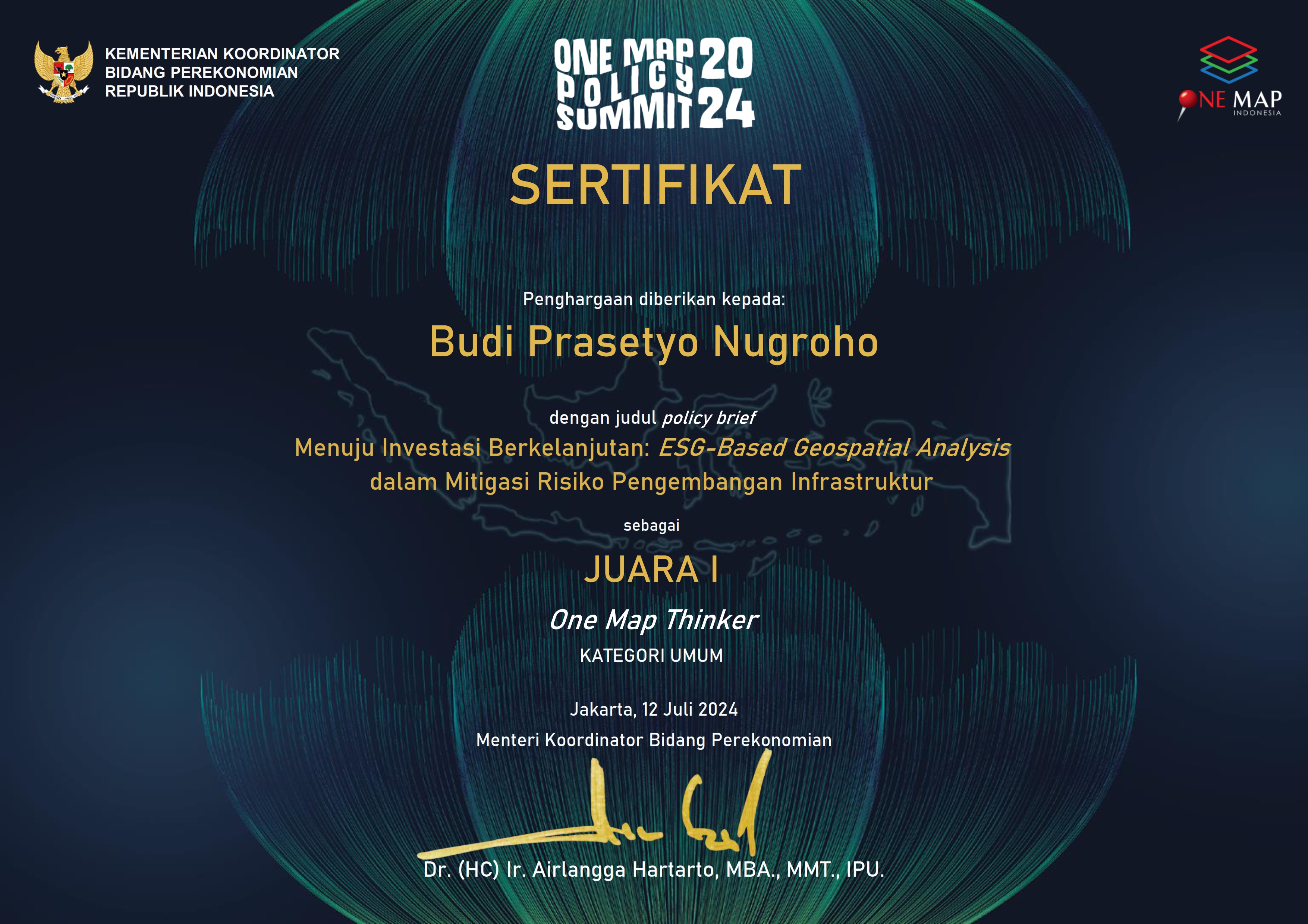
I'm Budi Prasetyo Nugroho, a Top Rated Plus GIS on upwork & Remote Sensing Specialist, Photogrammetries, Hydrologist, and WebGIS Developer. I bring over 8 years of seasoned experience and a proven track record of excellence to every project I undertake.

GIS Specialist & Remote Sensing Specialist
Specializing in Digital Mapping, Land Surveying, Photogrammetry, 3D Modeling, Website and Webmap Creation, and more. Proficient in industry-standard software and committed to delivering accurate and detailed results.
- Birthday: 20 November 1992
- Website: www.budi-carto.my.id
- Phone/Whatsapp: +62 857 7374 5006
- City: Cimanggis, Depok, Indonesia
- Age: 31
- Degree: Bachelor Degree in Geography
- Email: budioibud@gmail.com
- Freelance: Available
I graduated from the University of Indonesia with a degree in Geography in January 2016 and am currently pursuing a degree in Water Resource Engineering at UI. My professional experience includes extensive work in Detail Engineering Design for dams, web map development, photogrammetry, spatial planning, and expertise with GIS tools like ArcGIS Online and QGIS.
Facts
With over 8 years of experience, I have delivered exceptional results in various GIS, Remote Sensing, and Hydrology projects, earning the trust and satisfaction of numerous clients worldwide.
Happy Clients delivering top-notch solutions
Projects successfully completed
Hours Of Support provided
Hard Workers on my team
Skills
Proficient in a wide range of industry-standard software and programming languages, ensuring efficient and precise project execution.
Resume
Dedicated and highly skilled GIS Specialist with over 8 years of experience in remote sensing, hydrology, photogrammetry, and web map development. Proven track record of delivering high-quality results on time and within budget.
Summary
Budi Prasetyo Nugroho
Innovative and deadline-driven GIS Specialist with extensive experience in remote sensing, web map development, hydrology, and photogrammetry.
- Jl. Swadaya 1 RT 02 RW 11 No 242 Mekarsari, Cimanggis, Depok
- +62 857 7374 5006
- budioibud@gmail.com
Education
Bachelor of Science in Geographical Science
2011 - 2016
Universitas Indonesia, Depok
Specialized in GIS and Remote Sensing, focusing on problem-solving solutions in geographical sciences.
Professional Experience
GIS Officer
April 2016 - December 2017
ABT Associate (NGO), East Jakarta City
- Supported Trimble Team in creating IMS (Information Management System) and WebGIS using flexy cadaster software for OSS (One Stop Service - PTSP) and Planning Agencies (Bappeda) in Mamasa District, Mamuju District, Muaro Jambi District, Merangin District.
- Worked on the Green Prosperity project accommodated by Millennium Challenge Account Indonesia (MCAI).
GIS and Geodetic Engineer
Jan 2017 - November 2017
PT Pangripta Geomatika Indonesia, East Jakarta City
- Managed Ground Control System using multispectral, RGB, and LIDAR drones.
- Conducted geodetic surveys to create GCP & ICP and performed static and Real Time Kinematic (RTK) surveys.
- Processed and analyzed multispectral data.
GIS and Photogrammetry Specialist
Jan 2018 - June 2018
Center for Environmental Research, Bogor Agricultural University, Bogor City
- Assembled multispectral drones and managed data.
- Conducted geodetic surveys to create GCP for multispectral mapping.
- Processed and analyzed multispectral data.
GIS Analyst
June 2018 - December 2018
PT Reka Spasia Indonesia, Central Jakarta City
- Managed and created maps for spatial planning (RDTR) in Jatiluhur Dam and Patimban Port.
GIS Analyst
June 2019 - December 2019
World Resource Institute, Depok City
- Manipulated and consolidated palm oil concession area data from various sources and verified with satellite data.
Analyst Spatial and Regional Mapping
Maret 2020 - December 2021
Ministry of Public Works and Housing, Central Jakarta City
- Created thematic maps and managed, manipulated, and analyzed GIS data.
- Conducted field surveys, focus group discussions, and coordination with other institutions.
GIS Specialist - Associate Consulting Engineer
Jan 2021 - September 2022
ACE Pakistan Ltd., South Jakarta City
- Managed GIS & Geodetic data for Digital Engineering Design for Warsamson and Rongkong Dam.
- Created thematic maps such as suitable area for planned irrigation, inundated areas in downstream and upstream dams, site plans for dams, and land use maps.
- Supervised LIDAR and topographic mapping by sub-consultancy, mapped reservoir areas using drones, and prepared Dambreak Study and Emergency Action Plan reports.
Freelance GIS Specialist
Jan 2023 - Present
Upwork
- Skilled in remote sensing, hydrology, and hydraulics.
- Expert in analyzing spatial data, conducting remote sensing analyses, and applying advanced hydrological and hydraulic modeling techniques.
- Proficient in GIS software such as ArcGIS, QGIS, ENVI, and ERDAS Imagine.
- Ensured the accuracy and reliability of spatial datasets, collaborating effectively with cross-functional teams to deliver high-quality results within specified timelines.


Services
Offering a wide range of services in GIS, remote sensing, hydrology, and web map development. From data analysis and management to project implementation and technical support, I am dedicated to delivering exceptional results tailored to your needs.
GIS Data Management
Comprehensive management of GIS data, ensuring accuracy and efficiency in project execution.
Remote Sensing Analysis
Expert analysis of remote sensing data, including satellite and UAV data, for various applications.
Hydrology and Hydraulics
Advanced hydrological and hydraulic modeling for detailed engineering design and analysis.
Web Map Development
Creation and management of interactive web maps using industry-standard platforms.
GIS Training and Support
Providing technical support and user training services to ensure effective GIS implementation.
3D Modeling and Analysis
3D modeling and analysis using digital elevation models for various geospatial applications.
Contact
If you have any questions or would like to discuss a project, please feel free to reach out. I'm available for consultations and collaborations.
Location:
Jl. Radar Auri No. 3, Mekarsari, Kec. Cimanggis, Kota Depok, Jawa Barat
Email:
Call:
+62 857 7374 5006